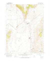
1964 Map of Gerlach
USGS Topo · Published 1977About this map
Gerlach sits at the gateway to the high desert, positioned between the Smoke Creek Desert and the Black Rock Desert in this mid-1960s survey. The town's industrial and logistical importance is evident through the path of the Western Pacific railroad and the nearby community of Empire, which is supported by an Aerial Tramway and several Gravel Pits. The arid landscape is defined by its water sources, from the Great Boiling Spring Park just north of town to remote reaches like Texas Basin Spring and Double Spout Spring. High points in the terrain include Selenite Peak and the Granite Range, while historical landmarks like Deephole Ranch and the local Cem provide grounding for genealogical research. The presence of multiple Landing Strips and a Radio Tower underscores the region's role as a transportation and communication hub in the expansive Nevada interior.
Find a feature on this map
43 named features on this map. Tap any name to fly to it.
Don’t see what you’re looking for? This feature index may not catch every label — zoom into the map to look around manually.
Map Details
Editions of this 1964 Gerlach Map
2 editions found
Other maps of this area

1886 · Granite Range
USGS Topo · 1:250,000

1894 · Granite Range
USGS Topo · 1:250,000

1955 · Lovelock
USGS Topo · 1:250,000

1959 · Lovelock
USGS Topo · 1:250,000

1964 · Gerlach
USGS Topo · 1:62,500

1964 · Kumiva Peak
USGS Topo · 1:62,500

1965 · Fox Range
USGS Topo · 1:62,500

1980 · Dry Mountain NW
USGS Topo · 1:24,000
1980 · The Banjo
USGS Topo · 1:24,000

1980 · Tenmile
USGS Topo · 1:24,000