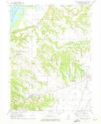
1971 Map of Germantown Hills
USGS Topo · Published 1973About this map
Germantown Hills and the surrounding woodlands of Worth township define the landscape of this 1971 study, where residential growth begins to intersect with established rural landmarks. The Mount Alverno Novitiate sits near the southern edge, while the village itself is flanked by several civic and religious sites, including the Germantown Hills Ch and the Wernsman Landing Strip. The terrain is deeply dissected by a network of waterways like Partridge Creek and Mundinger Creek, which flow toward the Upper Peoria Lake and the Woodford County State Conservation Area in the northwest. Several historic burial grounds, such as Black Partridge Cem and Lone Hill Cem, are preserved across the ridges, providing valuable locations for genealogical research. The presence of the Gulf Mobile And Ohio railroad and the Proving Ground area suggests the varied land use in this part of Woodford County during the early 1970s.
Find a feature on this map
45 named features on this map. Tap any name to fly to it.
Don’t see what you’re looking for? This feature index may not catch every label — zoom into the map to look around manually.
Map Details
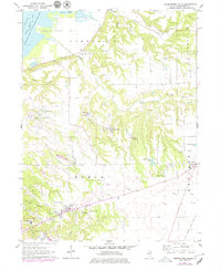
Editions of this 1971 Germantown Hills Map
2 editions found
Other maps of this area

1893 · Metamora
USGS Topo · 1:62,500

1893 · Dunlap
USGS Topo · 1:62,500

1898 · Dunlap
USGS Topo · 1:62,500

1905 · Peoria
USGS Topo · 1:62,500

1927 · Peoria
USGS Topo · 1:62,500

1928 · Mackinaw
USGS Topo · 1:62,500

1932 · Mackinaw
USGS Topo · 1:62,500

1932 · Dunlap
USGS Topo · 1:62,500

1933 · Dunlap
USGS Topo · 1:62,500

1937 · Metamora
USGS Topo · 1:62,500