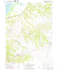
1971 Map of Germantown Hills
USGS Topo · Published 1979About this map
Upper Peoria Lake and the Illinois River dominate the northwest corner of this Woodford County landscape, where the Woodford County State Conservation Area protects the wetlands around Goose Lake. The topography is defined by the deep incisions of Partridge Creek and Richland Creek as they drain toward the river valley. The growing settlement of Germantown Hills is visible in the southwest, complete with its municipal facilities and the Wernsman Landing Strip. This era shows a transition from traditional rural patterns to modern suburban expansion, with family-named landmarks like the Black Partridge Cem and Winkler Cem preserved alongside newer developments. The eastern edge is marked by the Gulf Mobile and Ohio railroad corridor, while recreational sites such as Camp Wildwood and Izaak Walton Lake highlight the area's use for regional leisure.
Find a feature on this map
45 named features on this map. Tap any name to fly to it.
Don’t see what you’re looking for? This feature index may not catch every label — zoom into the map to look around manually.
Map Details
Editions of this 1971 Germantown Hills Map
2 editions found
Other maps of this area

1893 · Metamora
USGS Topo · 1:62,500

1893 · Dunlap
USGS Topo · 1:62,500

1898 · Dunlap
USGS Topo · 1:62,500

1905 · Peoria
USGS Topo · 1:62,500

1927 · Peoria
USGS Topo · 1:62,500

1928 · Mackinaw
USGS Topo · 1:62,500

1932 · Mackinaw
USGS Topo · 1:62,500

1932 · Dunlap
USGS Topo · 1:62,500

1933 · Dunlap
USGS Topo · 1:62,500

1937 · Metamora
USGS Topo · 1:62,500