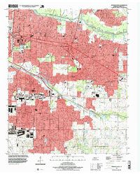
1997 Map of Germantown
USGS Topo · Published 1999About this map
The suburban expansion of eastern Memphis into Germantown is clearly visible in this late-1990s update of a mid-century survey. The landscape is defined by a heavy concentration of institutional and recreational sites, ranging from prestigious private schools like Memphis University Sch and Hutchison Sch to the winding corridors of Wolf River in the north and Nonconnah Creek in the south. The transition from established neighborhoods like White Station to the developing area of Forest Hill reflects the eastward shift of the region's population. Local landmarks such as Memphis Memorial Park Cemetery and Walnut Grove Lake provide anchoring points for genealogical research and community history. This map documents a period when rural land was rapidly giving way to residential developments, interconnected by major thoroughfares like Poplar Road and Winchester Road.
Find a feature on this map
41 named features on this map. Tap any name to fly to it.
Don’t see what you’re looking for? This feature index may not catch every label — zoom into the map to look around manually.
Map Details
Editions of this 1997 Germantown Map
This is the sole edition of this map. No revisions or reprints were ever made.
Other maps of this area

1943 · Collierville
USGS Topo · 1:62,500

1944 · Hernando
USGS Topo · 1:62,500

1948 · Byhalia
USGS Topo · 1:62,500

1953 · Collierville
USGS Topo · 1:50,000

1956 · Blytheville
USGS Topo · 1:250,000

1956 · Tupelo
USGS Topo · 1:250,000

1958 · Tupelo
USGS Topo · 1:250,000

1959 · Blytheville
USGS Topo · 1:250,000

1960 · Bartlett
USGS Topo · 1:62,500

1961 · Bartlett
USGS Topo · 1:62,500