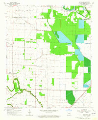
1964 Map of Gethsemane
USGS Topo · Published 1965About this map
Gethsemane serves as the focal point of this rural Jefferson County landscape, situated amidst a complex network of waterways including Wabbaseka Bayou and Indian Woman Bayou. This 1960s survey documents a lowland region defined by its drainage and early aviation markers, such as the Coy Landing Strip and Henderson Landing Strip. The settlement pattern is anchored by local religious and educational centers, including McClung Sch and several country churches like Oak Grove Ch and St Stephen Ch. To the south, the St Louis Southwestern railroad cuts through Dunnington, connecting this agricultural pocket to larger transport corridors. The map provides a detailed view of the transition from the wetlands of Cash Brake to the cultivated fields near Plum Bayou, reflecting the mid-century engineering of the Arkansas delta.
Find a feature on this map
31 named features on this map. Tap any name to fly to it.
Don’t see what you’re looking for? This feature index may not catch every label — zoom into the map to look around manually.
Map Details
Editions of this 1964 Gethsemane Map
2 editions found
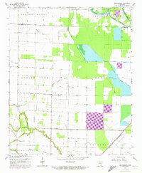
Other maps of this area

1935 · Altheimer
USGS Topo · 1:62,500

1937 · Stuttgart
USGS Topo · 1:62,500

1937 · England
USGS Topo · 1:48,000

1939 · Stuttgart
USGS Topo · 1:62,500

1941 · Goldman
USGS Topo · 1:62,500

1943 · England
USGS Topo · 1:62,500

1948 · Helena
USGS Topo · 1:250,000

1950 · Helena
USGS Topo · 1:250,000

1955 · Helena
USGS Topo · 1:250,000

1959 · Helena
USGS Topo · 1:250,000