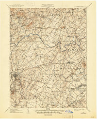
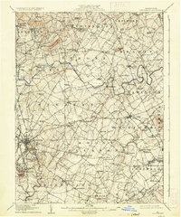
1908 Map of Gettysburg
USGS Topo · Published 1946About this map
The Gettysburg Battlefield Commission provided control for this detailed landscape of Adams County, documenting the sacred terrain just decades after the Civil War. Significant tactical landmarks such as Round Top, Little Round Top, and Cemetery Hill are clearly delineated alongside Seminary Ridge and Barlow Knoll, offering a precise view of the topography that shaped the 1863 conflict. Beyond the battlefield, the map reveals a thriving early 20th-century rural economy anchored by milling and rail transit, with Hershey Mill and Goodintent Mills situated along the winding creeks.
Find a feature on this map
142 named features on this map. Tap any name to fly to it.
Don’t see what you’re looking for? This feature index may not catch every label — zoom into the map to look around manually.
Map Details
Editions of this 1908 Gettysburg Map
6 editions found
Other maps of this area

1904 · Carlisle
USGS Topo · 1:62,500

1905 · Westminster
USGS Topo · 1:62,500

1906 · New Cumberland
USGS Topo · 1:62,500

1908 · Gettysburg
USGS Topo · 1:62,500

1909 · Fairfield
USGS Topo · 1:62,500

1911 · Taneytown
USGS Topo · 1:62,500

1911 · Emmitsburg
USGS Topo · 1:62,500

1919 · Newville
USGS Topo · 1:62,500

1920 · Hanover
USGS Topo · 1:62,500

1922 · Hanover
USGS Topo · 1:62,500