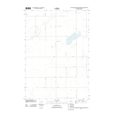
2012 Map of Gettysburg Municipal Airport SW
USGS Topo · Published 2012About this map
Cottonwood Lake and Mundt Lake anchor this rural landscape in Sully County, marking the prairie terrain east of the Missouri River. This map reveals a late-twentieth-century agricultural grid, where section lines are defined by long north-south thoroughfares like 310th Ave and 313th Ave. The drainage of Okobojo Cr meanders across the northern and western sections of the township, providing a natural break in the otherwise rigid geometry of the local road network. These intermittent waterways and scattered prairie potholes represent the essential hydrology of the Great Plains, influencing the placement of early farmsteads and field boundaries. The map provides a clear record of the rural infrastructure, including secondary routes such as Mustang Pl and 177th St, illustrating the enduring pattern of land division in this part of South Dakota.
Find a feature on this map
22 named features on this map. Tap any name to fly to it.
Don’t see what you’re looking for? This feature index may not catch every label — zoom into the map to look around manually.
Map Details
Editions of this 2012 Gettysburg Municipal Airport SW Map
This is the sole edition of this map. No revisions or reprints were ever made.
Other maps of this area

1953 · Huron
USGS Topo · 1:250,000

1954 · Pierre
USGS Topo · 1:250,000

1954 · Huron
USGS Topo · 1:250,000

1958 · Pierre
USGS Topo · 1:250,000

1965 · Agar
USGS Topo · 1:24,000
1967 · Blunt NW
USGS Topo · 1:24,000

1967 · Blunt NE
USGS Topo · 1:24,000
1970 · Agar NE
USGS Topo · 1:24,000

1974 · Gettysburg Municipal Airport SE
USGS Topo · 1:24,000
1974 · Gettysburg Muni. Airport NE
USGS Topo · 1:24,000