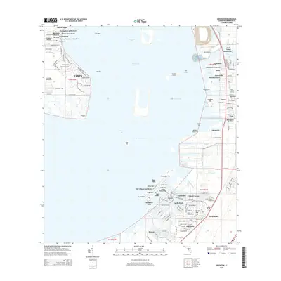
2015 Map of Gibsonton
USGS Topo · Published 2015About this map
Hillsborough Bay and the eastern shores of Tampa Bay dominate this 2015 perspective of the Florida coast. The landscape is defined by the heavy footprint of modern residential development and managed waterways, seen in the intricate canal systems of Apollo Beach and the planned layouts of Mirabay and Southshore Falls. North of these developments, the Alafia River reaches the bay near the established community of Gibsonton, where the South Channel and Alafia River Channel show the area's importance to coastal navigation. Small, localized settlements such as Gardenville, Adamsville, and Allens are visible along the corridor of the older Old US 41A and Phillips Highway, while the Interbay Peninsula and Gadsden Point define the western reaches of the water. The presence of numerous keys and shoals, including Whiskey Stump Key and Long Bar, illustrates the shallow, complex nature of the bay floor.
Find a feature on this map
152 named features on this map. Tap any name to fly to it.
Don’t see what you’re looking for? This feature index may not catch every label — zoom into the map to look around manually.
Map Details
Editions of this 2015 Gibsonton Map
This is the sole edition of this map. No revisions or reprints were ever made.
Other maps of this area

1921 · Tampa
USGS Topo · 1:62,500

1921 · Fort De Soto
USGS Topo · 1:62,500

1921 · St Petersburg
USGS Topo · 1:62,500

1942 · Cockroach Bay
USGS Topo · 1:31,680

1943 · Gandy Bridge
USGS Topo · 1:31,680

1943 · Port Tampa
USGS Topo · 1:31,680

1944 · Mango
USGS Topo · 1:31,680

1944 · Ruskin
USGS Topo · 1:31,680

1944 · Tampa
USGS Topo · 1:31,680

1944 · Wimauma
USGS Topo · 1:31,680