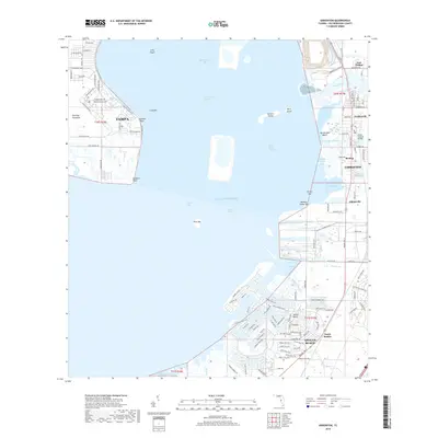
2018 Map of Gibsonton
USGS Topo · Published 2018About this map
The Alafia River and its South Channel define the coastal landscape of eastern Tampa Bay, where the river meets the Gulf Of Mexico. This coastal region is marked by a series of developed residential waterfronts and managed waterways, including Hog and Hominy Cove and the Big Bend Channel. The map illustrates the growth of communities like Gibsonton and Apollo Beach, showing a complex network of suburban streets and coastal infrastructure. The Doyle Carlton Bridge spans Bullfrog Creek, connecting the established settlements of Gardenville and Remlap to the industrial and residential corridors of East Tampa. Inland, the landscape is punctuated by named waterways such as Newman Branch and Jackson Br, while the bay contains several distinctive landmarks like Whiskey Stump Key and Pine Key. The spatial layout reveals the transition from the Interbay Peninsula across to the expanding residential developments of North Ruskin and Adamsville.
Find a feature on this map
134 named features on this map. Tap any name to fly to it.
Don’t see what you’re looking for? This feature index may not catch every label — zoom into the map to look around manually.
Map Details
Editions of this 2018 Gibsonton Map
This is the sole edition of this map. No revisions or reprints were ever made.
Other maps of this area

1921 · Tampa
USGS Topo · 1:62,500

1921 · Fort De Soto
USGS Topo · 1:62,500

1921 · St Petersburg
USGS Topo · 1:62,500

1942 · Cockroach Bay
USGS Topo · 1:31,680

1943 · Gandy Bridge
USGS Topo · 1:31,680

1943 · Port Tampa
USGS Topo · 1:31,680

1944 · Mango
USGS Topo · 1:31,680

1944 · Ruskin
USGS Topo · 1:31,680

1944 · Tampa
USGS Topo · 1:31,680

1944 · Wimauma
USGS Topo · 1:31,680