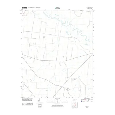
2010 Map of Gift
USGS Topo · Published 2010About this map
The Hatchie River meanders across the northern landscape of this Tipton County quadrangle, defining a complex wetland environment where Richland Creek and Flat Creek converge. The terrain is a patchwork of agricultural plots and low-lying drainage basins, punctuated by family and community landmarks that reflect the area's rural heritage. Aviation and fire monitoring infrastructure appear through the Covington Municipal Airport, Thurmond Glenn Field, and the Tabernacle Lookout Tower, indicating the region's modernization and forest management practices in the early 21st century.
Find a feature on this map
53 named features on this map. Tap any name to fly to it.
Don’t see what you’re looking for? This feature index may not catch every label — zoom into the map to look around manually.
Map Details
Editions of this 2010 Gift Map
This is the sole edition of this map. No revisions or reprints were ever made.
Other maps of this area

1952 · Stanton
USGS Topo · 1:24,000

1952 · Stanton
USGS Topo · 1:62,500

1954 · Mason
USGS Topo · 1:62,500

1956 · Blytheville
USGS Topo · 1:250,000

1959 · Blytheville
USGS Topo · 1:250,000

1961 · Rialto
USGS Topo · 1:62,500

1962 · Rialto
USGS Topo · 1:62,500
1964 · Turnpike
USGS Topo · 1:24,000
1964 · Durhamville
USGS Topo · 1:24,000

1965 · Brighton
USGS Topo · 1:24,000