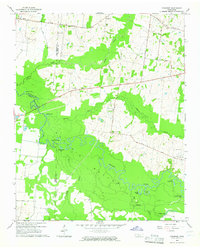
1964 Map of Turnpike
USGS Topo · Published 1965About this map
The Hatchie Bottom dominates this landscape, where the meandering Hatchie River carves a complex network of oxbows and wetlands across the borders of Haywood, Lauderdale, and Tipton Counties. The terrain is defined by its water, featuring numerous named basins such as Horseshoe Lake, Round Hole Lake, and Cutoff Lake. These features, along with Big Muddy Creek and Cypress Creek, illustrate the hydrologic character of the West Tennessee lowlands before modern extensive drainage altered many such systems.
Find a feature on this map
35 named features on this map. Tap any name to fly to it.
Don’t see what you’re looking for? This feature index may not catch every label — zoom into the map to look around manually.
Map Details
Editions of this 1964 Turnpike Map
2 editions found
Other maps of this area

1950 · Brownsville
USGS Topo · 1:24,000

1951 · Brownsville
USGS Topo · 1:24,000

1952 · Stanton
USGS Topo · 1:24,000

1952 · Dancyville
USGS Topo · 1:24,000

1952 · Stanton
USGS Topo · 1:62,500

1954 · Mason
USGS Topo · 1:62,500

1956 · Blytheville
USGS Topo · 1:250,000

1959 · Blytheville
USGS Topo · 1:250,000

1961 · Rialto
USGS Topo · 1:62,500

1962 · Rialto
USGS Topo · 1:62,500