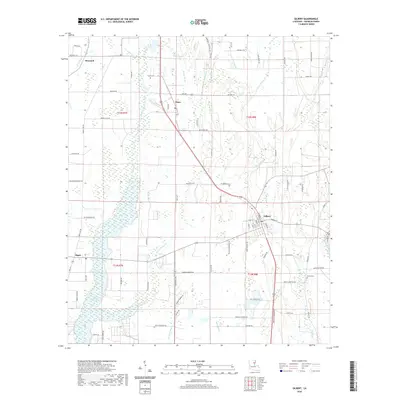
2020 Map of Gilbert
USGS Topo · Published 2020About this map
Gilbert serves as a primary hub in this low-lying region of Franklin Parish, where the local economy and landscape are shaped by an intricate network of waterways. The settlement of Chase sits to the north, while the winding course of the Bayou Macon River defines the eastern boundary of the survey. The terrain is characterized by numerous slow-moving water bodies, including Stokes Bayou, Ash Slough, and Black Bayou, which drain the surrounding agricultural lands. This 2020 map documents the modern footprint of rural Louisiana, showing the persistence of local landmarks such as Chase Cem and the waters of Turkey Creek Lake. The layout of roads like Dummy Line Rd and Turn Row Rd reflects the long-standing agricultural patterns of the delta, while the presence of the Po in Gilbert marks the town as a focal point for the surrounding countryside of Jigger and Brownell.
Find a feature on this map
86 named features on this map. Tap any name to fly to it.
Don’t see what you’re looking for? This feature index may not catch every label — zoom into the map to look around manually.
Map Details
Editions of this 2020 Gilbert Map
This is the sole edition of this map. No revisions or reprints were ever made.
Other maps of this area

1935 · Winnsboro
USGS Topo · 1:62,500

1939 · Fort Necessity
USGS Topo · 1:62,500

1941 · Sicily Island
USGS Topo · 1:62,500

1941 · Harrisonburg
USGS Topo · 1:62,500

1953 · Natchez
USGS Topo · 1:250,000

1955 · Jackson
USGS Topo · 1:250,000

1956 · Natchez
USGS Topo · 1:250,000

1957 · Sicily Island
USGS Topo · 1:62,500

1958 · Winnsboro
USGS Topo · 1:62,500

1958 · Fort Necessity
USGS Topo · 1:62,500