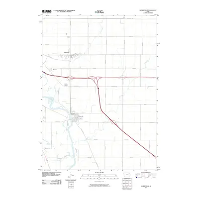
2010 Map of Gilbertville
USGS Topo · Published 2010About this map
Gilbertville and Raymond anchor this Black Hawk County landscape, where the meandering course of the Cedar River meets a network of modern transit. The map documents the spatial relationship between the historic community centers and the expanding highway infrastructure that bypasses the smaller settlements of Raymar. For family historians, the sheet is particularly dense with burial sites and parish landmarks, including Saint Joseph's Cemetery near the Raymond Post Office and the Saint Marys Catholic Cemetery located in the heart of Gilbertville. The drainage patterns of Poyner Creek and Indian Creek illustrate the classic Iowa floodplain topography, while smaller landmarks like Flyers Airport point to the varied land use of the early 21st century. The map provides a clear look at the rural road grid, from Jubilee Rd to Independence Ave, defining the agricultural plots that surround these riverside towns.
Find a feature on this map
43 named features on this map. Tap any name to fly to it.
Don’t see what you’re looking for? This feature index may not catch every label — zoom into the map to look around manually.
Map Details
Editions of this 2010 Gilbertville Map
This is the sole edition of this map. No revisions or reprints were ever made.
Other maps of this area

1954 · Waterloo
USGS Topo · 1:250,000

1955 · Waterloo
USGS Topo · 1:250,000

1963 · Waterloo South
USGS Topo · 1:24,000

1963 · Eagle Center
USGS Topo · 1:24,000

1963 · Waterloo North
USGS Topo · 1:24,000

1971 · Gilbertville
USGS Topo · 1:24,000

1971 · La Porte City
USGS Topo · 1:24,000
1971 · Brandon
USGS Topo · 1:24,000

1971 · Dunkerton
USGS Topo · 1:24,000

1971 · Littleton
USGS Topo · 1:24,000