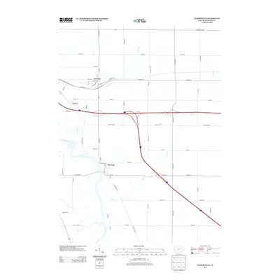
2013 Map of Gilbertville
USGS Topo · Published 2013About this map
The Cedar River winding through Black Hawk County anchors this 2013 landscape, where the agricultural legacy of the Midwest meets modern transportation corridors. The settlement of Gilbertville sits near the riverbanks, served by a network of local routes including Gilbertville Rd and Fox Rd. Further north, the communities of Raymond and Raymar are situated along the historic path of Dubuque Rd, a significant east-west artery through the region. This topographic study captures the area's hydrology in detail, showing how Poyner Creek and Indian Creek drain the surrounding farmlands. The map reveals the shift from traditional grid-based local roads to the expansive highway interchanges that now define the movement of goods and people across the Iowa prairie. Researchers can trace the proximity of small towns to these evolving transit systems while following the natural meandering of the local creek systems.
Find a feature on this map
53 named features on this map. Tap any name to fly to it.
Don’t see what you’re looking for? This feature index may not catch every label — zoom into the map to look around manually.
Map Details
Editions of this 2013 Gilbertville Map
This is the sole edition of this map. No revisions or reprints were ever made.
Other maps of this area

1954 · Waterloo
USGS Topo · 1:250,000

1955 · Waterloo
USGS Topo · 1:250,000

1963 · Waterloo South
USGS Topo · 1:24,000

1963 · Eagle Center
USGS Topo · 1:24,000

1963 · Waterloo North
USGS Topo · 1:24,000

1971 · Gilbertville
USGS Topo · 1:24,000

1971 · La Porte City
USGS Topo · 1:24,000
1971 · Brandon
USGS Topo · 1:24,000

1971 · Dunkerton
USGS Topo · 1:24,000

1971 · Littleton
USGS Topo · 1:24,000