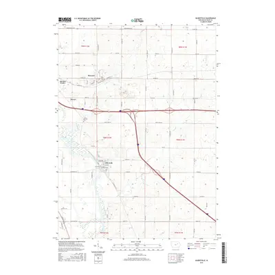
2015 Map of Gilbertville
USGS Topo · Published 2015About this map
Gilbertville and its surrounding townships in Black Hawk County show a landscape defined by the winding course of the Cedar River and its many tributaries. The area's spiritual and community history is anchored by several distinct burial grounds, including Saint Marys Catholic Cem and Saint Josephs Cem, which serve as vital touchstones for family historians. Smaller settlements like Raymond and Raymar are situated along a grid of section roads and modern highway corridors, illustrating the persistent agricultural and residential patterns of eastern Iowa. The drainage network of Indian Cr and Poyner Cr carves through the terrain, influencing the placement of secondary routes like Poyner Rd and Indian Creek Rd. This survey documents the intersection of traditional township boundaries, such as t88n r12w, with the expanding footprints of communities like Elk Run Heights.
Find a feature on this map
59 named features on this map. Tap any name to fly to it.
Don’t see what you’re looking for? This feature index may not catch every label — zoom into the map to look around manually.
Map Details
Editions of this 2015 Gilbertville Map
This is the sole edition of this map. No revisions or reprints were ever made.
Other maps of this area

1954 · Waterloo
USGS Topo · 1:250,000

1955 · Waterloo
USGS Topo · 1:250,000

1963 · Waterloo South
USGS Topo · 1:24,000

1963 · Eagle Center
USGS Topo · 1:24,000

1963 · Waterloo North
USGS Topo · 1:24,000

1971 · Gilbertville
USGS Topo · 1:24,000

1971 · La Porte City
USGS Topo · 1:24,000
1971 · Brandon
USGS Topo · 1:24,000

1971 · Dunkerton
USGS Topo · 1:24,000

1971 · Littleton
USGS Topo · 1:24,000