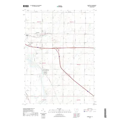
2018 Map of Gilbertville
USGS Topo · Published 2018About this map
The Cedar River corridor dominates this section of Black Hawk County, winding past the established communities of Evansdale and Gilbertville. This 2018 survey documents the intricate network of tributaries feeding the river, including Miller Cr and the multi-branched Poyner Cr. The landscape is a mix of small-town residential centers and expansive rural tracts, with the city of Elk Run Heights and the village of Raymond situated along the northern transport routes. Genealogists will find significant detail in the mapping of local burial grounds, such as Saint Josephs Cem and Poyner Township Cem. The map provides a clear picture of the modern infrastructure connecting these settlements, from major thoroughfares like Independence Ave to local connectors like Gilbertville Rd and Poyner Rd.
Find a feature on this map
67 named features on this map. Tap any name to fly to it.
Don’t see what you’re looking for? This feature index may not catch every label — zoom into the map to look around manually.
Map Details
Editions of this 2018 Gilbertville Map
This is the sole edition of this map. No revisions or reprints were ever made.
Other maps of this area

1954 · Waterloo
USGS Topo · 1:250,000

1955 · Waterloo
USGS Topo · 1:250,000

1963 · Waterloo South
USGS Topo · 1:24,000

1963 · Eagle Center
USGS Topo · 1:24,000

1963 · Waterloo North
USGS Topo · 1:24,000

1971 · Gilbertville
USGS Topo · 1:24,000

1971 · La Porte City
USGS Topo · 1:24,000
1971 · Brandon
USGS Topo · 1:24,000

1971 · Dunkerton
USGS Topo · 1:24,000

1971 · Littleton
USGS Topo · 1:24,000