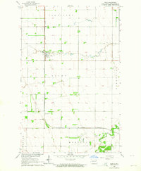
1963 Map of Gilby
USGS Topo · Published 1964About this map
The Northern Pacific railroad corridor anchors this survey of northern Grand Forks County, cutting a straight north-south line through the Red River Valley. The village of Gilby serves as the primary hub, surrounded by a grid of townships including Johnstown, Mekinock, and Hegton. This agricultural landscape is defined by its extreme flatness, where only the winding course of the Turtle River and the occasional shelterbelt break the geometric precision of section lines and field boundaries.
Find a feature on this map
12 named features on this map. Tap any name to fly to it.
Don’t see what you’re looking for? This feature index may not catch every label — zoom into the map to look around manually.
Map Details
Editions of this 1963 Gilby Map
This is the sole edition of this map. No revisions or reprints were ever made.
Other maps of this area

1926 · Ardoch
USGS Topo · 1:62,500

1934 · Emerado
USGS Topo · 1:48,000

1936 · Emerado
USGS Topo · 1:62,500

1936 · Larimore
USGS Topo · 1:62,500

1952 · Grand Forks
USGS Topo · 1:250,000

1952 · Thief River Falls
USGS Topo · 1:250,000

1956 · Thief River Falls
USGS Topo · 1:250,000

1956 · Grand Forks
USGS Topo · 1:250,000

1957 · Thief River Falls
USGS Topo · 1:250,000

1963 · Larimore East
USGS Topo · 1:24,000