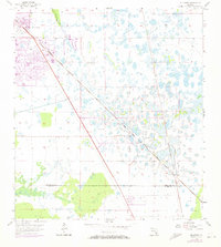
1957 Map of Gilchrist
USGS Topo · Published 1973About this map
The Seaboard Coast Line Railroad cuts a sharp diagonal through this 1970s-revised landscape, marking the transition between the expanding residential footprints of South Punta Gorda Heights and Tropical Gulf Acres and the untamed wetlands to the east. This survey, which includes aerial revisions from 1972, documents the early phases of suburban development in Charlotte County. To the southeast, the small settlement of Gilchrist sits near the Charlotte Co - Lee Co line, representing a quieter pocket of the region's historical geography. The terrain is defined by a dense network of marshes and scattered water bodies, including the South Prong Alligator Creek and a notably placed Flowing Well in the center of the sheet. The proximity of these water features to the growing residential grids provides a clear look at the environmental challenges and land-use changes occurring in Southwest Florida during the mid-twentieth century.
Find a feature on this map
7 named features on this map. Tap any name to fly to it.
Don’t see what you’re looking for? This feature index may not catch every label — zoom into the map to look around manually.
Map Details
Editions of this 1957 Gilchrist Map
3 editions found
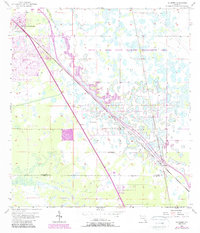
Other maps of this area

1956 · Cleveland
USGS Topo · 1:24,000

1956 · Punta Gorda SE
USGS Topo · 1:24,000

1956 · Bermont
USGS Topo · 1:24,000

1956 · West Palm Beach
USGS Topo · 1:250,000

1956 · Tampa
USGS Topo · 1:250,000

1956 · Charlotte Harbor
USGS Topo · 1:250,000

1957 · West Palm Beach
USGS Topo · 1:250,000

1957 · Tuckers Corner
USGS Topo · 1:24,000

1957 · Punta Gorda
USGS Topo · 1:24,000

1957 · Gilchrist
USGS Topo · 1:24,000