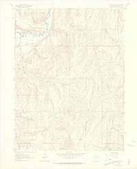
1962 Map of Gillam Draw
USGS Topo · Published 1965About this map
The White River carves through the northern reaches of this Rio Blanco County terrain, defined by the prominent Coal Oil Rim and the sprawling drainages of the Big Ridge. In the early 1960s, this landscape was a mix of cattle country and emerging energy infrastructure, evidenced by a Pipeline crossing the river and a Pumping Sta located near the riverbank. A network of Jeep Trails and unnamed trails provides the primary access through the dissected topography of Gillam Draw and Spring Creek. Isolated human markers, such as the Hefley Cabin near the southern border and various mapped Oil Wells and Drill Holes, speak to the region's historical reliance on ranching and resource extraction. The map also captures local landmarks like the Basin Reservoir and the Rocky Ford Draw, essential water-related features in this arid environment.
Find a feature on this map
31 named features on this map. Tap any name to fly to it.
Don’t see what you’re looking for? This feature index may not catch every label — zoom into the map to look around manually.
Map Details
Editions of this 1962 Gillam Draw Map
2 editions found
Other maps of this area

1907 · Rangely
USGS Topo · 1:125,000

1910 · Rangely
USGS Topo · 1:125,000

1954 · Vernal
USGS Topo · 1:250,000

1956 · Grand Junction
USGS Topo · 1:250,000

1958 · Vernal
USGS Topo · 1:250,000

1959 · Grand Junction
USGS Topo · 1:250,000

1960 · Vernal
USGS Topo · 1:250,000

1960 · Grand Junction
USGS Topo · 1:250,000

1962 · Grand Junction
USGS Topo · 1:250,000

1962 · Rangely NE
USGS Topo · 1:24,000