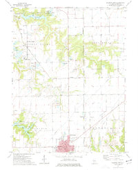
1974 Map of Gillespie North
USGS Topo · Published 1977About this map
Gillespie and its neighbor East Gillespie anchor the southern portion of this mid-1970s landscape, which illustrates a transition from agricultural land to industrial and recreational utility. The presence of the Monterey Mine No 1 and the surrounding Gillespie-Wyen Oil Field highlights the region's reliance on subsurface resources. Transport infrastructure is prominent, with the Illinois Terminal and the Chicago and North Western railroad lines cutting through the terrain to connect local industry and settlements like Henderson and Monterey Siding.
Find a feature on this map
49 named features on this map. Tap any name to fly to it.
Don’t see what you’re looking for? This feature index may not catch every label — zoom into the map to look around manually.
Map Details
Editions of this 1974 Gillespie North Map
This is the sole edition of this map. No revisions or reprints were ever made.
Other maps of this area

1912 · Gillespie
USGS Topo · 1:62,500

1915 · Gillespie
USGS Topo · 1:62,500

1915 · Mount Olive
USGS Topo · 1:62,500

1923 · Carlinville
USGS Topo · 1:48,000

1923 · Raymond
USGS Topo · 1:62,500

1925 · Carlinville
USGS Topo · 1:62,500

1925 · Raymond
USGS Topo · 1:62,500

1931 · Carlinville
USGS Topo · 1:62,500

1944 · Mount Olive
USGS Topo · 1:62,500

1958 · Decatur
USGS Topo · 1:250,000