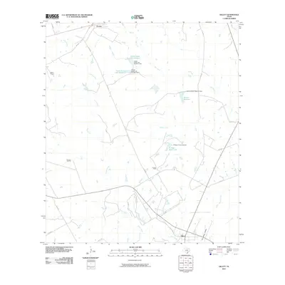
2010 Map of Gillett
USGS Topo · Published 2010About this map
Gillett and Pandora anchor this Karnes County landscape at the turn of the 21st century, where the rural economy is defined by ranching and resource extraction. The area's hydrology is dominated by the winding course of Ecleto Creek, which is joined by several smaller tributaries including Shockley Creek and Mustang Creek. This era of land use is characterized by a series of private water improvements, notably the Weinert Reservoir and the tiered lakes of the Coates Estate Lake Number 1 and Coates Estate Lake Number 2. Industrial activity is centered on the Manford Gas Field in the west, while transportation is facilitated by a network of farm-to-market roads and county routes. Local family names are preserved through landmarks like El Negro Ranch and the southern Tom White Hollow, providing essential reference points for genealogists tracing modern property boundaries and family holdings in the region.
Find a feature on this map
30 named features on this map. Tap any name to fly to it.
Don’t see what you’re looking for? This feature index may not catch every label — zoom into the map to look around manually.
Map Details
Editions of this 2010 Gillett Map
This is the sole edition of this map. No revisions or reprints were ever made.
Other maps of this area

1920 · Smiley
USGS Topo · 1:125,000

1942 · Dewville
USGS Topo · 1:62,500

1953 · Seguin
USGS Topo · 1:250,000

1956 · Dewville
USGS Topo · 1:62,500

1958 · Seguin
USGS Topo · 1:250,000

1960 · Kosciusko
USGS Topo · 1:24,000

1961 · Nixon
USGS Topo · 1:24,000
1961 · Stockdale
USGS Topo · 1:24,000
1961 · Alum
USGS Topo · 1:24,000

1961 · Gillett
USGS Topo · 1:24,000