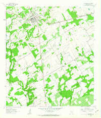
1961 Map of Stockdale
USGS Topo · Published 1963About this map
Stockdale serves as the focal point of this 1961 survey, where the Southern Pacific Railroad Grade intersects with a landscape defined by ranching and oil exploration. Significant cattle operations like Dale Valley Ranch and Lazy S Ranch are interspersed with industrial features including the Scotty Field and various Oil Wells. The community of Denhawken to the southeast provides a glimpse into local rural life, anchored by the Denhawken Cem and the Dilworth Ranch Sch. Following the winding path of Cibolo Creek, the map details a region transitioning from its rail-dependent origins toward a modern infrastructure of pipelines and improved roadways. Notable landmarks like St Marys Ch and St Johns Ch highlight the religious hubs that supported these Wilson County families during the early 1960s.
Find a feature on this map
26 named features on this map. Tap any name to fly to it.
Don’t see what you’re looking for? This feature index may not catch every label — zoom into the map to look around manually.
Map Details
Editions of this 1961 Stockdale Map
2 editions found
Other maps of this area

1920 · Smiley
USGS Topo · 1:125,000

1936 · Floresville
USGS Topo · 1:62,500

1942 · Dewville
USGS Topo · 1:62,500

1953 · Seguin
USGS Topo · 1:250,000

1954 · San Antonio
USGS Topo · 1:250,000

1956 · Dewville
USGS Topo · 1:62,500

1957 · San Antonio
USGS Topo · 1:250,000

1958 · Seguin
USGS Topo · 1:250,000

1960 · Kosciusko
USGS Topo · 1:24,000

1961 · Nixon
USGS Topo · 1:24,000