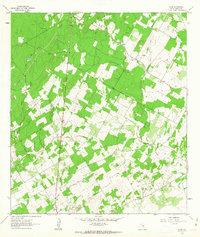
1961 Map of Alum
USGS Topo · Published 1963About this map
Nockenut and Alum serve as the primary settlement markers in this early 1960s landscape, which is defined by a rural economy shifting between traditional agriculture and growing petroleum extraction. The drainage patterns of Ecleto Creek and Alum Creek dictate the local geography, with family history etched into the land via numerous small burial grounds like Neyland Cem and Leach Cem. The emergence of the Scotty Oil Field and Ecleto Oil Field reflects the mid-century industrial expansion into this part of Texas, showing the placement of specific Oil Wells and a major Pipeline cutting across the terrain. Small community life is represented by the Missionary Ch near Caddo, while industrial artifacts like Claypits indicate other local resource uses beyond the oil patch.
Find a feature on this map
23 named features on this map. Tap any name to fly to it.
Don’t see what you’re looking for? This feature index may not catch every label — zoom into the map to look around manually.
Map Details
Editions of this 1961 Alum Map
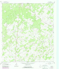
2 editions found
Other maps of this area

1920 · Smiley
USGS Topo · 1:125,000

1936 · Floresville
USGS Topo · 1:62,500

1942 · Dewville
USGS Topo · 1:62,500

1953 · Seguin
USGS Topo · 1:250,000

1954 · San Antonio
USGS Topo · 1:250,000

1956 · Dewville
USGS Topo · 1:62,500

1957 · San Antonio
USGS Topo · 1:250,000

1957 · New Berlin
USGS Topo · 1:24,000

1958 · Seguin
USGS Topo · 1:250,000

1961 · Nixon
USGS Topo · 1:24,000