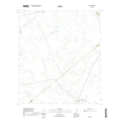
2019 Map of Gillett
USGS Topo · Published 2019About this map
The settlement of Gillett sits at the intersection of farm-to-market roads and county routes in this 2019 survey of the South Texas brush country. The landscape is defined by the winding course of Ecleto Cr, which meanders through the western half of the quadrangle, joined by tributaries such as Elm Cr and Shockley Cr. To the north, the community of Pandora marks the boundary near the Wilson and Karnes County line. The area's land use is characterized by large estates and ranches, evidenced by the private waters of Coates Estate Lake Number 1, Coates Estate Lake Number 2, and El Negro Ranch Lake. Aviators and local historians will note Bailey Airport situated on the western edge of the map, while topographic features like Tom White Hollow and Mustang Cr provide distinct landmarks for those studying the drainage patterns and historical property lines of this rural ranching region.
Find a feature on this map
31 named features on this map. Tap any name to fly to it.
Don’t see what you’re looking for? This feature index may not catch every label — zoom into the map to look around manually.
Map Details
Editions of this 2019 Gillett Map
This is the sole edition of this map. No revisions or reprints were ever made.
Other maps of this area

1920 · Smiley
USGS Topo · 1:125,000

1942 · Dewville
USGS Topo · 1:62,500

1953 · Seguin
USGS Topo · 1:250,000

1956 · Dewville
USGS Topo · 1:62,500

1958 · Seguin
USGS Topo · 1:250,000

1960 · Kosciusko
USGS Topo · 1:24,000

1961 · Nixon
USGS Topo · 1:24,000
1961 · Stockdale
USGS Topo · 1:24,000
1961 · Alum
USGS Topo · 1:24,000

1961 · Gillett
USGS Topo · 1:24,000