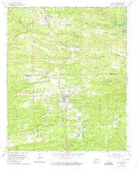
1964 Map of Gillham
USGS Topo · Published 1975About this map
The Kansas City Southern railroad serves as the primary corridor through this portion of the Ouachita region, connecting the rural communities of Gillham, Grannis, and King. Surveyed in the early 1960s, the map documents a landscape defined by several freshwater sources, including Mineral Spring, Holly Springs Spring, and the rising waters of Gillham Lake on the eastern edge. Local life is anchored by dispersed landmarks such as School No 47, the High Sch in Gillham, and a Lookout Tower positioned for forest monitoring.
Find a feature on this map
29 named features on this map. Tap any name to fly to it.
Don’t see what you’re looking for? This feature index may not catch every label — zoom into the map to look around manually.
Map Details
Editions of this 1964 Gillham Map
2 editions found
Other maps of this area

1913 · De Queen
USGS Topo · 1:125,000

1950 · Mcalester
USGS Topo · 1:250,000

1959 · Umpire
USGS Topo · 1:62,500

1959 · Cove
USGS Topo · 1:62,500

1962 · McAlester
USGS Topo · 1:250,000

1964 · Gillham Dam
USGS Topo · 1:24,000

1964 · Gillham
USGS Topo · 1:24,000

1965 · McAlester
USGS Topo · 1:250,000
1965 · Chapel Hill
USGS Topo · 1:24,000
1966 · De Queen
USGS Topo · 1:24,000