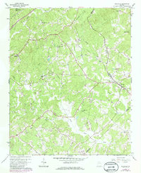
1964 Map of Gillsville
USGS Topo · Published 1985About this map
The North Oconee River and its numerous tributaries, including Buffington Mill Creek and Candler Creek, carve through this section of the Georgia Piedmont during the mid-1960s. The settlement of Gillsville serves as a local hub along the Southern railroad line, which tracks through the rolling landscape. This survey captures a rural network of small-scale agriculture and community centers, evidenced by the concentration of country churches such as White Hall Ch, Antioch Ch, and Midway Ch.
Find a feature on this map
29 named features on this map. Tap any name to fly to it.
Don’t see what you’re looking for? This feature index may not catch every label — zoom into the map to look around manually.
Map Details
Editions of this 1964 Gillsville Map
3 editions found
Other maps of this area

1891 · Gainesville
USGS Topo · 1:125,000

1954 · Greenville
USGS Topo · 1:250,000

1958 · Greenville
USGS Topo · 1:250,000

1964 · Maysville
USGS Topo · 1:24,000

1964 · Chestnut Mountain
USGS Topo · 1:24,000

1964 · Lula
USGS Topo · 1:24,000

1964 · Gainesville
USGS Topo · 1:24,000

1964 · Pendergrass
USGS Topo · 1:24,000
1964 · Baldwin
USGS Topo · 1:24,000
1964 · Gillsville
USGS Topo · 1:24,000