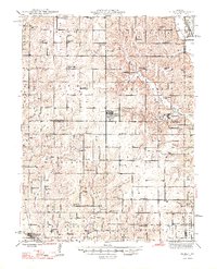
1948 Map of Gilman
USGS Topo · Published 1948About this map
Gilman City P O and the surrounding township of Sugar Creek anchor this mid-century survey of the rural landscape where Harrison, Daviess, and Grundy counties meet. The area is defined by a dense network of country schools such as Sherman Center Sch, Bondurant Sch, and Hazel Dell Sch, reflecting the community-centric agricultural life before the consolidation of rural districts. The Wabash railroad cuts through the southwestern corner, serving the town of Jameson near the banks of the Grand River.
Find a feature on this map
85 named features on this map. Tap any name to fly to it.
Don’t see what you’re looking for? This feature index may not catch every label — zoom into the map to look around manually.
Map Details
Editions of this 1948 Gilman Map
2 editions found

Other maps of this area

1921 · Chillicothe
USGS Topo · 1:62,500

1922 · Gallatin
USGS Topo · 1:62,500

1923 · Chillicothe
USGS Topo · 1:62,500

1924 · Winston
USGS Topo · 1:62,500

1925 · Pattonsburg
USGS Topo · 1:62,500

1925 · Gilman
USGS Topo · 1:62,500

1944 · Pattonsburg
USGS Topo · 1:62,500

1946 · Gilman
USGS Topo · 1:48,000

1946 · Pattonsburg
USGS Topo · 1:48,000

1946 · Princeton
USGS Topo · 1:62,500