
1944 Map of Gilman
USGS Topo · Published 1966About this map
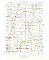
Gilman and the surrounding Iroquois County prairie appear in this mid-1940s landscape as a major crossroads for both rail and river traffic. The Illinois Central and the Toledo Peoria And Western railroads intersect here, defining the development of towns like Danforth, Ashkum, and Clifton. To the east, the Iroquois River meanders through the terrain, crossed by several named landmarks such as Fiddler Bridge and L'Erable Bridge.
Find a feature on this map
75 named features on this map. Tap any name to fly to it.
Don’t see what you’re looking for? This feature index may not catch every label — zoom into the map to look around manually.
Map Details
Editions of this 1944 Gilman Map
2 editions found
Other maps of this area

1922 · Momence
USGS Topo · 1:62,500

1922 · Kankakee
USGS Topo · 1:62,500

1923 · Herscher
USGS Topo · 1:62,500

1924 · Momence
USGS Topo · 1:62,500

1924 · Kankakee
USGS Topo · 1:62,500

1925 · Herscher
USGS Topo · 1:62,500

1935 · Watseka
USGS Topo · 1:48,000

1938 · Milford
USGS Topo · 1:48,000

1939 · Watseka
USGS Topo · 1:62,500

1939 · Cissna Park
USGS Topo · 1:62,500