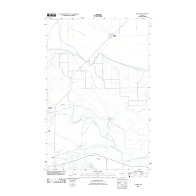
2011 Map of Gilman
USGS Topo · Published 2011About this map
Gilman sits at the heart of an intricate water management system in Lewis and Clark County, where the high plains meet the intricate hydraulics of the early 21st century. The landscape is defined by the heavy engineering of the Sun River Slope Canal and the Floweree Canal, which draw from the Sun River to support the local agricultural economy. This network of man-made waterways, including the Lytle Clemons Ditch, weaves around natural features like Gilman Hill and Meyer Hill, illustrating the complex relationship between the area's arid geography and its irrigation needs. To the south and east, the natural drainage of Elk Creek and Spring Creek contrasts with the straight-line precision of the gridded road system, while Basin Lake and Meyer Lake provide essential landmarks in this open ranching country. The presence of Hogan Slough and multiple coulees, such as Maloney Coulee, further emphasizes the specialized drainage patterns unique to this part of Montana.
Find a feature on this map
36 named features on this map. Tap any name to fly to it.
Don’t see what you’re looking for? This feature index may not catch every label — zoom into the map to look around manually.
Map Details
Editions of this 2011 Gilman Map
This is the sole edition of this map. No revisions or reprints were ever made.
Other maps of this area

1920 · Choteau
USGS Topo · 1:125,000

1943 · Hogan
USGS Topo · 1:125,000

1955 · Choteau
USGS Topo · 1:250,000

1957 · Choteau
USGS Topo · 1:250,000

1958 · Choteau
USGS Topo · 1:250,000

1960 · Gilman
USGS Topo · 1:62,500
1960 · Freezeout Lake
USGS Topo · 1:62,500

1962 · Choteau
USGS Topo · 1:250,000
1963 · Bowmans Corners NW
USGS Topo · 1:24,000
1963 · Augusta
USGS Topo · 1:24,000