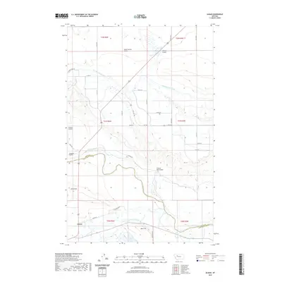
2020 Map of Gilman
USGS Topo · Published 2020About this map
Gilman lies on the western edge of this prairie landscape, where the agriculture of the Sun River valley relies on a sophisticated network of early twentieth-century irrigation infrastructure. The map documents the extensive reach of the Sun River Slope Canal and the Floweree Canal, which divert water across the plains through complex channels like the Lytle Clemons Ditch and Bickle Burke Ditch. These man-made features work in tandem with the natural drainages of School Section Coulee and Clemons Coulee, illustrating the critical role of water management in the development of the Montana frontier. To the east, the terrain rises toward Gilman Hill and Meyer Hill, overlooking the Sun River as it winds through the heart of the township. Local landmarks such as Meyer Lake and Basin Lake punctuate the grid of rural roads, offering clear reference points for those tracing family land holdings or early homestead footprints in this section of Lewis and Clark County.
Find a feature on this map
47 named features on this map. Tap any name to fly to it.
Don’t see what you’re looking for? This feature index may not catch every label — zoom into the map to look around manually.
Map Details
Editions of this 2020 Gilman Map
This is the sole edition of this map. No revisions or reprints were ever made.
Other maps of this area

1920 · Choteau
USGS Topo · 1:125,000

1943 · Hogan
USGS Topo · 1:125,000

1955 · Choteau
USGS Topo · 1:250,000

1957 · Choteau
USGS Topo · 1:250,000

1958 · Choteau
USGS Topo · 1:250,000

1960 · Gilman
USGS Topo · 1:62,500
1960 · Freezeout Lake
USGS Topo · 1:62,500

1962 · Choteau
USGS Topo · 1:250,000
1963 · Bowmans Corners NW
USGS Topo · 1:24,000
1963 · Augusta
USGS Topo · 1:24,000