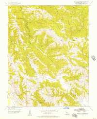
1955 Map of Gilroy Hot Springs
USGS Topo · Published 1957About this map
Gilroy Hot Springs and the surrounding Diablo Range backcountry are documented here during the mid-1950s, a period defined by rugged land use and early water management. The area is dominated by significant ridgelines like Palassou Ridge and Phegley Ridge, with the drainage of Coyote Creek cutting through the center of the sheet. Evidence of ranching and early development appears in labels for the Wilson Ranch and Center Flats, while the presence of a Pipeline and multiple reservoirs, including the Braen Reservoir, highlights the region's importance for water infrastructure. The southern portion of the map transitions into the broader valleys of Llano Del Tequisquita and San Ysidro Valley, providing a clear look at how the mountain terrain meets the agricultural flats of Santa Clara County.
Find a feature on this map
32 named features on this map. Tap any name to fly to it.
Don’t see what you’re looking for? This feature index may not catch every label — zoom into the map to look around manually.
Map Details
Editions of this 1955 Gilroy Hot Springs Map
4 editions found
Other maps of this area

1915 · San Juan Bautista
USGS Topo · 1:48,000

1917 · Morgan Hill
USGS Topo · 1:62,500

1917 · San Juan Bautista
USGS Topo · 1:62,500

1919 · Hollister
USGS Topo · 1:48,000

1921 · Gilroy Hot Springs
USGS Topo · 1:62,500

1921 · Hollister
USGS Topo · 1:62,500

1923 · Hollister
USGS Topo · 1:62,500

1939 · Morgan Hill
USGS Topo · 1:62,500

1939 · Gilroy Hot Springs
USGS Topo · 1:62,500

1939 · San Juan Bautista
USGS Topo · 1:62,500