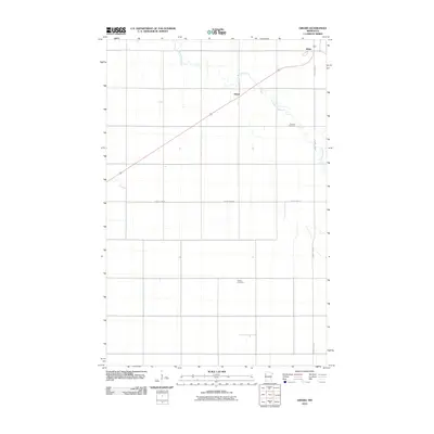
2010 Map of Girard
USGS Topo · Published 2010About this map
Burnham Creek winds through this agricultural landscape in Polk County, following a meandering path that breaks the rigid section lines of the surrounding prairie. This 2010 survey captures the quiet rural character of the area, centered on the small settlements of Girard and Wilds. The landscape is largely defined by its rectilinear road network, including County Hwy-14 and County Hwy-217, which facilitate the region's farming economy. Historical researchers will find significant genealogical sites such as Andover Cemetery situated near the creek and Hanna Cemetery further south. The path of Highway 75 cuts diagonally across the northern portion of the quadrangle, serving as the primary corridor connecting these remote communities to the larger regional centers like Crookston.
Find a feature on this map
9 named features on this map. Tap any name to fly to it.
Don’t see what you’re looking for? This feature index may not catch every label — zoom into the map to look around manually.
Map Details
Editions of this 2010 Girard Map
This is the sole edition of this map. No revisions or reprints were ever made.
Other maps of this area

1919 · Eldred
USGS Topo · 1:62,500

1919 · Beltrami
USGS Topo · 1:62,500

1952 · Grand Forks
USGS Topo · 1:250,000

1953 · Crookston
USGS Topo · 1:62,500

1956 · Grand Forks
USGS Topo · 1:250,000

1964 · Beltrami
USGS Topo · 1:24,000

1964 · Beltrami SW
USGS Topo · 1:24,000

1964 · Girard
USGS Topo · 1:24,000

1964 · Greenview
USGS Topo · 1:24,000
1964 · Climax
USGS Topo · 1:24,000