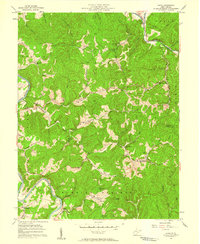
1957 Map of Girta
USGS Topo · Published 1958About this map
The Burning Springs Oil Field dominates the southern reaches of this mid-century survey, a region where early petroleum development shaped the West Virginia landscape. Numerous Oil Wells are scattered across the hills and valleys, particularly along Oil Rock Run and near the Burning Springs district. This industrial footprint is integrated into a landscape of small rural settlements and essential community structures, including Oil Rock Sch and Owl Hill Sch, which served the families living near the extraction sites.
Find a feature on this map
69 named features on this map. Tap any name to fly to it.
Don’t see what you’re looking for? This feature index may not catch every label — zoom into the map to look around manually.
Map Details
Editions of this 1957 Girta Map
4 editions found
Other maps of this area

1906 · Elizabeth
USGS Topo · 1:62,500

1907 · Harrisville
USGS Topo · 1:62,500

1907 · Arnoldsburg
USGS Topo · 1:62,500

1907 · Spencer
USGS Topo · 1:62,500

1924 · Harrisville
USGS Topo · 1:62,500

1924 · Elizabeth
USGS Topo · 1:62,500

1925 · Arnoldsburg
USGS Topo · 1:62,500

1926 · Elizabeth
USGS Topo · 1:62,500

1926 · Harrisville
USGS Topo · 1:62,500

1927 · Arnoldsburg
USGS Topo · 1:62,500