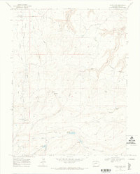
1969 Map of Glade Park
USGS Topo · Published 1973About this map
Glade Park and the surrounding high desert plateau are defined by a complex network of canyons and water management features captured during this 1960s survey. The landscape transitions from the residential cluster and Cem in the north toward the expansive Colorado National Monument boundary. Significant infrastructure for livestock and irrigation is evident in the presence of Schrader Reservoir, King Reservoir, and the Thompson Ditch, which redirect water across the arid terrain. The map records several distinctive geological formations and steep access routes, including Monument Rock, the Face, and the winding Jacobs Ladder trail. These features highlight the challenge of navigating the deep incisions of No Thoroughfare Canyon and Ladder Canyon, while named points like Clarks Bench provide orientation across the broad upland expanses.
Find a feature on this map
40 named features on this map. Tap any name to fly to it.
Don’t see what you’re looking for? This feature index may not catch every label — zoom into the map to look around manually.
Map Details
Editions of this 1969 Glade Park Map
3 editions found
Other maps of this area

1934 · Colorado National Monument
USGS Topo · 1:24,000

1956 · Moab
USGS Topo · 1:250,000

1956 · Grand Junction
USGS Topo · 1:250,000

1959 · Grand Junction
USGS Topo · 1:250,000

1959 · Moab
USGS Topo · 1:250,000

1960 · Moab
USGS Topo · 1:250,000

1960 · Grand Junction
USGS Topo · 1:250,000

1962 · Moab
USGS Topo · 1:250,000

1962 · Grand Junction
USGS Topo · 1:250,000

1962 · Colorado National Monument
USGS Topo · 1:24,000