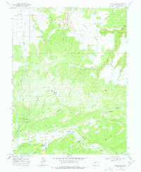
1969 Map of Glade Park
USGS Topo · Published 1978About this map
Glade Park transitions from the high plateaus of Clarks Bench into a complex network of drainage basins and canyons during the late 1960s. The landscape is defined by its water management and distinct landmarks, including the prominent Monument Rock and various high-altitude water sources like Monument Spr and Thrailkill Spring. Several reservoirs, such as Schrader Reservoir, Gobbo Reservoir, and King Reservoir, reflect the area's agricultural and livestock requirements. Local travel routes are marked by steep transitions, most notably the winding path of Jacobs Ladder and numerous Jeep Trails that navigate the ridges between Miller Canyon and the deep cut of No Thoroughfare Canyon. A small Cem in the north and the Thompson Ditch system indicate the long-standing human efforts to inhabit and irrigate this arid corner of the Colorado plateau.
Find a feature on this map
36 named features on this map. Tap any name to fly to it.
Don’t see what you’re looking for? This feature index may not catch every label — zoom into the map to look around manually.
Map Details
Editions of this 1969 Glade Park Map
3 editions found
Other maps of this area

1934 · Colorado National Monument
USGS Topo · 1:24,000

1956 · Moab
USGS Topo · 1:250,000

1956 · Grand Junction
USGS Topo · 1:250,000

1959 · Grand Junction
USGS Topo · 1:250,000

1959 · Moab
USGS Topo · 1:250,000

1960 · Moab
USGS Topo · 1:250,000

1960 · Grand Junction
USGS Topo · 1:250,000

1962 · Moab
USGS Topo · 1:250,000

1962 · Grand Junction
USGS Topo · 1:250,000

1962 · Colorado National Monument
USGS Topo · 1:24,000