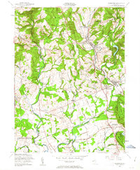
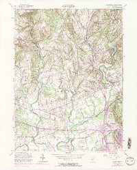
1954 Map of Gladstone
USGS Topo · Published 1963About this map
Pottersville and the neighboring hills of Tewksbury define this mid-century landscape where agricultural valleys meet the rise of the Somerset hills. The terrain is marked by institutional landmarks and summer retreats, including St Bernards Sch, St Johns Academy, and Camp St John. In the eastern section, the Delaware Lackawanna and Western railroad corridor serves the villages of Peapack, Gladstone, and Far Hills, reflecting a well-established rail-and-commuter infrastructure.
Find a feature on this map
77 named features on this map. Tap any name to fly to it.
Don’t see what you’re looking for? This feature index may not catch every label — zoom into the map to look around manually.
Map Details
Editions of this 1954 Gladstone Map
5 editions found
Other maps of this area

1888 · Hackettstown
USGS Topo · 1:62,500

1888 · Lake Hopatcong
USGS Topo · 1:62,500

1890 · High Bridge
USGS Topo · 1:62,500

1891 · Somerville
USGS Topo · 1:62,500

1893 · Somerville
USGS Topo · 1:62,500

1894 · Hackettstown
USGS Topo · 1:62,500

1894 · Lake Hopatcong
USGS Topo · 1:62,500

1898 · Lake Hopatcong
USGS Topo · 1:62,500

1898 · Hackettstown
USGS Topo · 1:62,500

1898 · High Bridge
USGS Topo · 1:62,500
Featured Places
- Bridgewater Township, NJ
- Readington Township, NJ
- Bedminster Township, NJ
- Bernardsville, NJ
- Far Hills, NJ