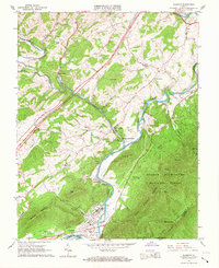
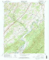
1965 Map of Glasgow
USGS Topo · Published 1967About this map
Glasgow sits at the strategic confluence of the Maury River and James River, serving as a vital industrial and transit hub in the mid-1960s. The landscape is defined by the sharp convergence of the Norfolk and Western and C & O railroads, which parallel the riverbanks to support local operations like the claypit and various Quarries. To the north, the historic community of Buffalo Forge and the Buffalo Forge Station mark a legacy of early iron industry along Buffalo Creek. The map documents a deeply established rural social fabric, preserved through landmarks such as Mt Lidia Cem, Wesley Chapel, and Poplar Hill Ch. Rising sharply from the river valley, the terrain transitions into the George Washington National Forest, where the Appalachian Trail traverses the heights of Sallings Mountain and the Three Sisters Knobs.
Find a feature on this map
50 named features on this map. Tap any name to fly to it.
Don’t see what you’re looking for? This feature index may not catch every label — zoom into the map to look around manually.
Map Details
Editions of this 1965 Glasgow Map
2 editions found
Other maps of this area

1894 · Natural Bridge
USGS Topo · 1:125,000

1894 · Lexington
USGS Topo · 1:125,000

1894 · Natural Bridge
USGS Topo · 1:62,500

1907 · Natural Bridge Special
USGS Topo · 1:62,500

1932 · Lexington
USGS Topo · 1:48,000

1935 · Buena Vista
USGS Topo · 1:48,000

1937 · Lexington
USGS Topo · 1:62,500

1939 · Buena Vista
USGS Topo · 1:62,500

1940 · Buena Vista
USGS Topo · 1:62,500
1946 · Millboro
USGS Topo · 1:62,500