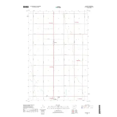
2017 Map of Glasston
USGS Topo · Published 2017About this map
Glasston and St. Thomas serve as the primary hubs in this section of the Red River Valley, characterized by a highly organized grid of rural roads and drainage infrastructure. This area of Pembina County relies on engineered water management systems like County Ditch Number 67A and County Ditch Number 67D, which channel water toward Willow Cr to support the region's productive agricultural landscape. The township structure is clearly delineated, showing the intersection of Industry Rd and Main St at the southern edge of the quadrangle. Local landmarks such as the St Thomas Municipal Airport and Saint Thomas Cem provide specific points of interest for genealogists and local historians tracking family roots in the northern plains. The map's detail preserves the 21st-century footprint of these small North Dakota communities and their surrounding section lines.
Find a feature on this map
32 named features on this map. Tap any name to fly to it.
Don’t see what you’re looking for? This feature index may not catch every label — zoom into the map to look around manually.
Map Details
Editions of this 2017 Glasston Map
This is the sole edition of this map. No revisions or reprints were ever made.
Other maps of this area
1939 · Glasston
USGS Topo · 1:62,500
1939 · Cavalier
USGS Topo · 1:62,500
1941 · Glasston
USGS Topo · 1:62,500
1941 · Cavalier
USGS Topo · 1:62,500
1941 · Bathgate
USGS Topo · 1:62,500
1944 · Crystal
USGS Topo · 1:62,500
1952 · Thief River Falls
USGS Topo · 1:250,000
1956 · Thief River Falls
USGS Topo · 1:250,000
1957 · Thief River Falls
USGS Topo · 1:250,000
1963 · Crystal SE
USGS Topo · 1:24,000