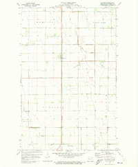
1971 Map of Glasston
USGS Topo · Published 1973About this map
The small settlement of Glasston serves as a focal point in this 1971 study of the Red River Valley’s agricultural heartland. Situated along the Burlington Northern railroad, the town is surrounded by the organized townships of Hamilton, Carlisle, St Thomas, and Midland. The landscape is defined by the rigid geometry of section lines and an extensive drainage system, including the prominent County Ditch, Willow Creek, and No 67A Creek. Near the southern boundary, the St Thomas Municipal Airfield and the St Thomas Cem provide specific points of interest for those researching the infrastructure and genealogy of Pembina County. The map provides an intricate view of a region dominated by large-scale farming, where nearly every acre is accessible by a network of well-maintained section-line roads.
Find a feature on this map
11 named features on this map. Tap any name to fly to it.
Don’t see what you’re looking for? This feature index may not catch every label — zoom into the map to look around manually.
Map Details
Editions of this 1971 Glasston Map
This is the sole edition of this map. No revisions or reprints were ever made.
Other maps of this area

1939 · Glasston
USGS Topo · 1:62,500

1939 · Cavalier
USGS Topo · 1:62,500

1941 · Glasston
USGS Topo · 1:62,500

1941 · Cavalier
USGS Topo · 1:62,500

1941 · Bathgate
USGS Topo · 1:62,500

1944 · Crystal
USGS Topo · 1:62,500

1952 · Thief River Falls
USGS Topo · 1:250,000

1956 · Thief River Falls
USGS Topo · 1:250,000

1957 · Thief River Falls
USGS Topo · 1:250,000

1963 · Crystal SE
USGS Topo · 1:24,000