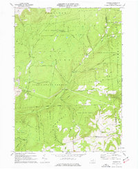
1970 Map of Gleason
USGS Topo · Published 1977About this map
Tioga State Forest dominates this landscape along the border of Tioga and Bradford counties, where the high elevations of Armenia Mountain and Huckleberry Mtn give way to a network of steep hollows and narrow creek bottoms. The small settlement of Gleason and the community at North Union serve as the primary points of human activity in the southern reach of the quadrangle. In the northwestern section, the terrain is marked by industrial activity, including several locations noted as Strip Mine near Fall Brook.
Find a feature on this map
31 named features on this map. Tap any name to fly to it.
Don’t see what you’re looking for? This feature index may not catch every label — zoom into the map to look around manually.
Map Details
Editions of this 1970 Gleason Map
4 editions found
Other maps of this area

1900 · Tioga
USGS Topo · 1:62,500

1902 · Tioga
USGS Topo · 1:62,500

1925 · Blossburg
USGS Topo · 1:62,500

1927 · Blossburg
USGS Topo · 1:62,500

1931 · Troy
USGS Topo · 1:48,000

1938 · Troy
USGS Topo · 1:62,500

1942 · Canton
USGS Topo · 1:62,500

1944 · Blossburg
USGS Topo · 1:62,500

1944 · Canton
USGS Topo · 1:62,500

1953 · Roseville
USGS Topo · 1:24,000