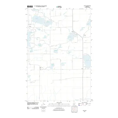
2010 Map of Glen
USGS Topo · Published 2010About this map
Glen and the small settlement of Glory anchor this central Minnesota landscape, characterized by a dense network of glacial lakes and wetlands. The terrain is defined by substantial water bodies such as Sisabagamah Lake and the Ripple River, which winds through the central section of the quadrangle. Local history is preserved through sites like the Bethlehem Cemetery and Rabbit Lake Cemetery, as well as the Calvary Baptist Cemetery near Glory. The presence of the Glen Lookout Tower and the Carrol Heft Dam on Section Ten Lake points to a landscape managed for both resource protection and water control. This survey provides a clear view of the rural road system, including Nuthatch Ave and Twp Hwy 101, connecting isolated farmsteads and timbered tracts across Aitkin County.
Find a feature on this map
67 named features on this map. Tap any name to fly to it.
Don’t see what you’re looking for? This feature index may not catch every label — zoom into the map to look around manually.
Map Details
Editions of this 2010 Glen Map
This is the sole edition of this map. No revisions or reprints were ever made.
Other maps of this area

1914 · Aitkin
USGS Topo · 1:62,500

1915 · Aitkin
USGS Topo · 1:62,500

1916 · Wealthwood
USGS Topo · 1:62,500

1953 · Duluth
USGS Topo · 1:250,000

1958 · Duluth
USGS Topo · 1:250,000

1969 · Thor SW
USGS Topo · 1:24,000

1969 · Thor
USGS Topo · 1:24,000

1970 · Kimberly
USGS Topo · 1:24,000
1973 · Hassman
USGS Topo · 1:24,000
1973 · Aitkin
USGS Topo · 1:24,000