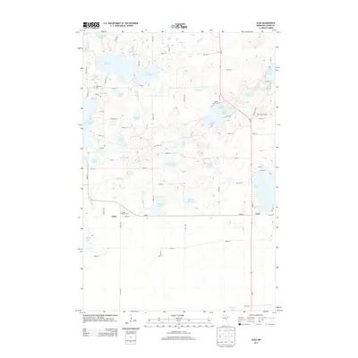
2013 Map of Glen
USGS Topo · Published 2013About this map
Sisabagamah Lake and its surrounding wetlands define the northern reaches of this Aitkin County landscape, where the Sisabagamah Cr flows toward a dense network of glacial lakes. Small settlements such as Glory and Glen are situated along the roadway network, serving as hubs for this rural lake district. The presence of the Glen Lookout Tower suggests the importance of fire observation over the heavily forested and bog-interspersed terrain that separates these waters. Local history is anchored by several burial sites, including Rabbit Lake Cem and Bethlehem Cem, which mark the community centers of previous generations. Moving south, the Ripple River meanders through the central portion of the map, connecting smaller bodies like Sjodin Lake and Monson Lake within a landscape defined by its intricate hydrography and township roads.
Find a feature on this map
77 named features on this map. Tap any name to fly to it.
Don’t see what you’re looking for? This feature index may not catch every label — zoom into the map to look around manually.
Map Details
Editions of this 2013 Glen Map
This is the sole edition of this map. No revisions or reprints were ever made.
Other maps of this area

1914 · Aitkin
USGS Topo · 1:62,500

1915 · Aitkin
USGS Topo · 1:62,500

1916 · Wealthwood
USGS Topo · 1:62,500

1953 · Duluth
USGS Topo · 1:250,000

1958 · Duluth
USGS Topo · 1:250,000

1969 · Thor SW
USGS Topo · 1:24,000

1969 · Thor
USGS Topo · 1:24,000

1970 · Kimberly
USGS Topo · 1:24,000
1973 · Hassman
USGS Topo · 1:24,000
1973 · Aitkin
USGS Topo · 1:24,000