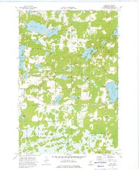
1973 Map of Glen
USGS Topo · Published 1976About this map
Wealthwood State Forest dominates the southern landscape of this Aitkin County quadrangle, where the northern shores of Mille Lacs Lake transition into the low-lying Mille Lacs Meadows. The 1970s terrain is characterized by an intricate network of water bodies, including the elongated Rabbit Lake and the smaller Sjodin Lake, connected by the winding Rice River. Settlement is concentrated around the small communities of Glen and Glory, with local landmarks like the Glen Lookout Tower and Clear Lake Parish House serving as points of orientation. Cultural sites such as Bethlehem Ch and the Rabbit Lake Cem provide valuable touchpoints for genealogists tracing family histories in the townships of Nordland and Malmo. The map reveals a rural economy shaped by natural resources, evidenced by scattered Gravel Pits and the managed timberlands of the state forest.
Find a feature on this map
43 named features on this map. Tap any name to fly to it.
Don’t see what you’re looking for? This feature index may not catch every label — zoom into the map to look around manually.
Map Details
Editions of this 1973 Glen Map
This is the sole edition of this map. No revisions or reprints were ever made.
Other maps of this area

1914 · Aitkin
USGS Topo · 1:62,500

1915 · Aitkin
USGS Topo · 1:62,500

1916 · Wealthwood
USGS Topo · 1:62,500

1953 · Duluth
USGS Topo · 1:250,000

1958 · Duluth
USGS Topo · 1:250,000

1969 · Thor SW
USGS Topo · 1:24,000

1969 · Thor
USGS Topo · 1:24,000

1970 · Kimberly
USGS Topo · 1:24,000
1973 · Hassman
USGS Topo · 1:24,000
1973 · Aitkin
USGS Topo · 1:24,000