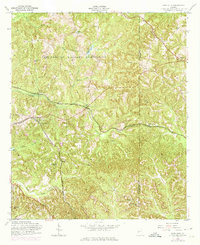
1955 Map of Glen Alta
USGS Topo · Published 1974About this map
The Fort Benning Military Reservation dominates the northern half of this terrain, where the Military Reservation Boundary cuts across the wooded hills of Chattahoochee and Marion counties. South of this line, a network of rural settlements and community landmarks highlights the mid-century landscape of West Georgia. The Central of Georgia railroad serves as a primary transit corridor, passing through the hamlets of Christopher, Vesper, and Glen Alta.
Find a feature on this map
30 named features on this map. Tap any name to fly to it.
Don’t see what you’re looking for? This feature index may not catch every label — zoom into the map to look around manually.
Map Details
Editions of this 1955 Glen Alta Map
Other maps of this area

1908 · Columbus
USGS Topo · 1:62,500

1929 · Columbus
USGS Topo · 1:48,000

1947 · Columbus
USGS Topo · 1:62,500

1949 · Glen Alta
USGS Topo · 1:24,000

1949 · Ochillee
USGS Topo · 1:24,000

1949 · Buena Vista NW
USGS Topo · 1:24,000

1949 · Cusseta
USGS Topo · 1:24,000

1950 · Louvale
USGS Topo · 1:24,000

1950 · Buena Vista NE
USGS Topo · 1:24,000

1950 · Buena Vista
USGS Topo · 1:24,000