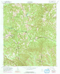
1955 Map of Glen Alta
USGS Topo · Published 1991About this map
The Fort Benning Military Reservation occupies the northern half of this landscape, where the wooded terrain is drained by Hallowa Creek and Hollis Branch. Outside the reservation boundary, the landscape of the mid-1950s is defined by a network of small rural communities and church-centered settlements. Transportation is anchored by the Central of Georgia and Seaboard Coast Line railroads, which intersect near Christopher and Ochillee. Local life centers on institutions like Liberty Hill Ch, St Mathews Sch, and Zion Hills Ch. Notable topographic landmarks such as Bush Hill and Gobblers Hill rise above the drainage basins of Hichitee Creek and Bagley Creek, illustrating the territory just before the purple-ink updates of the early 1970s noted changes near Glen Alta.
Find a feature on this map
34 named features on this map. Tap any name to fly to it.
Don’t see what you’re looking for? This feature index may not catch every label — zoom into the map to look around manually.
Map Details
Editions of this 1955 Glen Alta Map
Other maps of this area

1908 · Columbus
USGS Topo · 1:62,500

1929 · Columbus
USGS Topo · 1:48,000

1947 · Columbus
USGS Topo · 1:62,500

1949 · Glen Alta
USGS Topo · 1:24,000

1949 · Ochillee
USGS Topo · 1:24,000

1949 · Buena Vista NW
USGS Topo · 1:24,000

1949 · Cusseta
USGS Topo · 1:24,000

1950 · Louvale
USGS Topo · 1:24,000

1950 · Buena Vista NE
USGS Topo · 1:24,000

1950 · Buena Vista
USGS Topo · 1:24,000