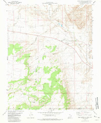
1981 Map of Glen Canyon City
USGS Topo · Published 1981About this map
Glen Canyon City stands as a focal point in this remote corner of Kane County, situated just north of the Utah-Arizona border. The landscape is defined by vast plateaus and seasonal watercourses, including Wahweap Creek and the deep incisions of Buck Tank Draw. Evidence of local industry and infrastructure is visible through numerous Gravel Pits and a Fish Hatchery located near a perennial well. The transition from the high East Clark Bench down toward the Glen Canyon National Recreation Area illustrates the dramatic desert topography of the region in the early 1980s. A network of trails and jeep trails provides access to remote landmarks like Cedar Mountain and the water source at Judd Hollow Spring.
Find a feature on this map
26 named features on this map. Tap any name to fly to it.
Don’t see what you’re looking for? This feature index may not catch every label — zoom into the map to look around manually.
Map Details
Editions of this 1981 Glen Canyon City Map
2 editions found
Other maps of this area

1886 · Escalante
USGS Topo · 1:250,000

1886 · Echo Cliffs
USGS Topo · 1:250,000

1891 · Echo Cliffs
USGS Topo · 1:250,000

1951 · Lees Ferry NE
USGS Topo · 1:24,000

1953 · Nipple Butte
USGS Topo · 1:62,500

1954 · Lees Ferry NW
USGS Topo · 1:24,000

1954 · Lees Ferry
USGS Topo · 1:62,500
1954 · Paria Plateau
USGS Topo · 1:62,500

1954 · Paria
USGS Topo · 1:62,500

1956 · Escalante
USGS Topo · 1:250,000