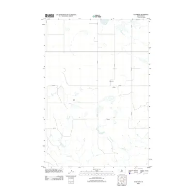
2012 Map of Glencross
USGS Topo · Published 2012About this map
The prairie landscape around Glencross is defined by its agricultural grid and distinct topographical landmarks. This area of South Dakota features Dog Butte, a prominent elevation that rises above the surrounding plains. The local community center of gravity is anchored by Sacred Heart Cem, located just south of the main settlement area. Water features are sparse but significant, including Spring Lake in the north and the winding drainage of Dog Butte Cr and Whitehorse Cr. The map reveals a highly structured road network, with numbered county routes like Co HWY-6 and Co HWY-8 providing the primary transit corridors through this rural expanse. The layout of these roads and the positioning of the small community of Glencross reflect a settlement pattern deeply tied to the township and range survey system.
Find a feature on this map
17 named features on this map. Tap any name to fly to it.
Don’t see what you’re looking for? This feature index may not catch every label — zoom into the map to look around manually.
Map Details
Editions of this 2012 Glencross Map
This is the sole edition of this map. No revisions or reprints were ever made.
Other maps of this area

1952 · Whitehorse
USGS Topo · 1:24,000

1952 · Glencross SE
USGS Topo · 1:24,000

1953 · McIntosh
USGS Topo · 1:250,000

1956 · Little Eagle SW
USGS Topo · 1:24,000

1956 · Little Eagle SE
USGS Topo · 1:24,000

1956 · Miscol SE
USGS Topo · 1:24,000

1958 · McIntosh
USGS Topo · 1:250,000

1975 · Glencross
USGS Topo · 1:24,000
1975 · Glencross NE
USGS Topo · 1:24,000

1978 · Timber Lake
USGS Topo · 1:24,000