
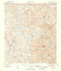
1951 Map of Glendale
USGS Topo · Published 1951About this map
The Alabama-Florida state line bisects this 1951 topographic study, where the pine-and-pond landscape of the Panhandle meets the southern reaches of the Conecuh National Forest. Small agricultural and timber-focused settlements like Gaskin, Glendale, and Leonia are established along a network of improved and unimproved roads, many of which lead to local centers of community life. Rural gathering places such as Limestone Ch, Cluster Springs Ch, and Pleasant Grove Ch are clearly marked, providing critical reference points for genealogists tracing family roots in Walton and Holmes counties.
Find a feature on this map
88 named features on this map. Tap any name to fly to it.
Don’t see what you’re looking for? This feature index may not catch every label — zoom into the map to look around manually.
Map Details
Editions of this 1951 Glendale Map
2 editions found
Other maps of this area

1934 · Niceville
USGS Topo · 1:48,000

1935 · De Funiak Springs
USGS Topo · 1:48,000

1936 · Niceville
USGS Topo · 1:62,500

1938 · De Funiak Springs
USGS Topo · 1:62,500

1942 · Enterprise
USGS Topo · 1:125,000

1948 · Ponce De Leon
USGS Topo · 1:24,000

1949 · Glendale
USGS Topo · 1:62,500

1949 · Laurel Hill
USGS Topo · 1:62,500

1949 · Hobbs Crossroads
USGS Topo · 1:24,000

1950 · Hobbs Cross Roads
USGS Topo · 1:24,000