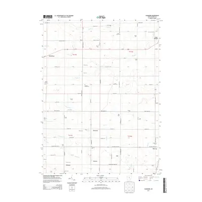
2013 Map of Glenmore
USGS Topo · Published 2013About this map
The agricultural landscape of southern Van Wert County is defined by a dense grid of family farms and drainage systems such as Lillick Ditch and Bowen Ditch. Small rural settlements and historic crossroads like Glenmore, Schumm, and Abanaka anchor the township sections, reflecting a community pattern established by 19th-century land grants. The map provides significant genealogical value, noting numerous family-named properties including Gardner Green Farm, Kiehl Farms, and Germann Farms, alongside established local cemeteries. Religious and civic history is represented by sites like the Evangelical Protestant Cem and Saint Marys Cem. Near the eastern margin, the outskirts of Van Wert and the village of Ohio City appear, connected by a network of county roads and the major corridor of Us-224, which cuts through the northern sections near Middlebury.
Find a feature on this map
113 named features on this map. Tap any name to fly to it.
Don’t see what you’re looking for? This feature index may not catch every label — zoom into the map to look around manually.
Map Details
Editions of this 2013 Glenmore Map
This is the sole edition of this map. No revisions or reprints were ever made.
Other maps of this area

1911 · Berne
USGS Topo · 1:48,000

1914 · Celina
USGS Topo · 1:62,500

1914 · Van Wert
USGS Topo · 1:62,500

1944 · Van Wert
USGS Topo · 1:62,500

1944 · Celina
USGS Topo · 1:62,500

1953 · Muncie
USGS Topo · 1:250,000

1956 · Muncie
USGS Topo · 1:250,000
1960 · Convoy
USGS Topo · 1:24,000

1960 · Dixon
USGS Topo · 1:24,000
1960 · Scott
USGS Topo · 1:24,000