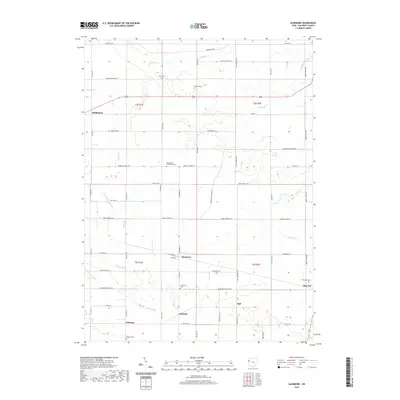
2019 Map of Glenmore
USGS Topo · Published 2019About this map
Glenmore and the surrounding agricultural landscape of Van Wert County are defined by a meticulous grid of township roads and drainage ditches in this modern-era study. The settlement pattern remains centered on small hamlets like Schumm, Abanaka, and the ironically named Dull, reflecting the area's deep roots in the rural Midwest. Genealogists will find a high density of burial sites scattered across the township, from the Evangelical Protestant Cem near the center of the quadrangle to the Glenn Cem and Balyeat Cem in the north. Waterways such as Hoaglin Cr and Maddox Cr meander through the landscape, frequently diverted or supplemented by engineered works like Lillick Ditch and Bowen Ditch to manage the fertile terrain. To the southeast, the larger community of Ohio City stands at the junction of several local routes, including Willshire Ohio City Rd, maintaining its role as a local hub amidst the vast stretches of farmland.
Find a feature on this map
38 named features on this map. Tap any name to fly to it.
Don’t see what you’re looking for? This feature index may not catch every label — zoom into the map to look around manually.
Map Details
Editions of this 2019 Glenmore Map
This is the sole edition of this map. No revisions or reprints were ever made.
Other maps of this area

1911 · Berne
USGS Topo · 1:48,000

1914 · Celina
USGS Topo · 1:62,500

1914 · Van Wert
USGS Topo · 1:62,500

1944 · Van Wert
USGS Topo · 1:62,500

1944 · Celina
USGS Topo · 1:62,500

1953 · Muncie
USGS Topo · 1:250,000

1956 · Muncie
USGS Topo · 1:250,000
1960 · Convoy
USGS Topo · 1:24,000

1960 · Dixon
USGS Topo · 1:24,000
1960 · Scott
USGS Topo · 1:24,000